“When I was in architecture school, I studied for a while at Hadrian’s Villa in Rome and two fabulous things happened,” says Hadley Arnold, founding co-director, with her husband Peter, of the Arid Lands Institute. “One, I was inspired by all this gorgeous water infrastructure that not only fed public space, but also added so much beauty and mystery to the complex. It was wonderful to see design, utility, and meaning working so closely side by side. And two, I met my husband. Ever since then, we’ve both been enchanted with water systems.”
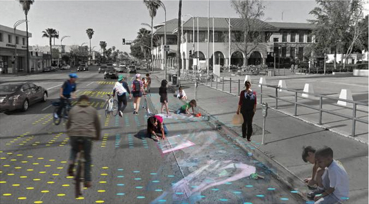
In the spirit of bringing practical and beautiful water infrastructure to the fore in public placemaking, the Arid Lands Institute’s Connect the Dots | Van Nuys project will gather together citizens, cyclists, and designers to envision Van Nuys Boulevard between Victory and Oxnard as a culturally and environmentally resilient Great Street. The project will aim to promote multimodal transit, engender vibrant public space, and optimize the hydrologic functions that are vital to Los Angeles’s future—including stormwater capture as well as more permeable streets, more cooling vegetation, and more shade.
“We think design should serve as a bridge between science and the public imagination,” says Hadley. “We know from scientific study that long-term drought is in the cards for California; now we want to take that information—and what we can do about it—to the community, in an appealing, accessible, visual way.”
Aja Bulla‐Richards, Creative Director for Connect the Dots, is leading that charge.
“Our streets already host a lot of shared codes,” she explains. “Stoplights, crosswalks, street signs, etc. With this project, we’re trying out some new shared codes about things critical to our future, like stormwater use. For example, a series of five-inch diameter blue dots painted on a street could indicate a place where rainwater should be captured for storage. A series of red dots could indicate an area where we wouldn’t want to collect water, like near a gas station. After a while, you see a kind of mural start to emerge. A data-derived mural, but still a mural!”
“People really respond to these kinds of playful visualizations,” says Aja. “They’re instantly understandable. They appeal to our curiosity. They make us think, ‘What is this space? What could it be?’ Then we can add other layers, like visualizations of where bike lanes or sidewalks could go. And then we can readily see how the locations of those different amenities would interact.”
Connect the Dots will hold three focus groups this fall (in English and Spanish) followed by three public workshops next year. The first workshop will allow participants to identify and mark features like underground streams, storage reservoirs, contamination sites, and storm drains on the street; the second will cull public opinion about how water capture systems, bike lanes, transit, walking paths, and other street amenities could better work together to support community life, and test out some temporary streetscapes; the third will implement and test the chosen streetscapes at full scale (using temporary materials). Then a culminating event—to include a barbecue, outdoor movies, dancing, trick riding, and more—will encourage neighbors to enjoy their new space. Participants will evaluate: How is this working? What would we change?, and the organizers will document the responses and perspectives.
“Our hope is that this is a demo project that will be one dot on an increasingly larger map,” says Hadley. “There’s no such thing as a Great Street in dry land unless it’s integrating stormwater capture and green transportation options. We want to scale and transport this to as many other streets in L.A. as possible.”
“This city’s architects, landscapers, and designers have given so much to it, and the city has given so much back to them. It’s such an incredible reciprocal arrangement that places have with people. I feel honored to be a part of this one.”