project leader
Melissa M
location
2080 Poplar Avenue
(Midtown)
latest update rss
Late summer trail project update

the project

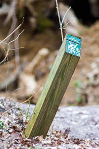
The Overton Park Old Forest State Natural Area is a beautiful escape into nature, and a favorite spot for runners and hikers.  But it can sometimes be confusing to navigate the trails.  Trail markers were last installed on the Old Forest Trail in the 1980s, and many of them are either missing, broken, or vandalized.  Overton Park Conservancy needs funds to replace these markers, as well as add a few mileage markers on the limestone running trail. 

We also want to help people understand what's so special about the forest.  There's a paper map from the 1980s with some interpretive information, but we want to put the map online so that we can update it as the forest changes.  Visitors will be able to use their phones or computers to learn more about what they're seeing on the Old Forest trails.  Any extra funds we raise beyond the cost of the trail markers will go toward developing and coding an interpretive trail map for our website.  

the steps

Spring 2015 - Identify locations for the new trail markers, and develop content for the interpretive map.

Summer 2015 - Work with Overton Park Conservancy's Design Advisory Committee to identify attractive trail markers that are helpful to visitors and enhance the forest's natural beauty.  After those are identified, we will order and install new trail markers for the Old Forest Trail.

Fall 2015 - Work with our web vendor to create interactive maps for the website.

why we're doing it

The Old Forest is one of Memphis' treasures--a 10,000+ year-old wooded ecosystem that has never been cut down.  It has more than 4 miles of dirt trails where people can immerse themselves in nature, with no admission fee, 365 days a year.  A 1.4-mile limestone running trail offers a free opportunity for fitness and recreation.  But we often hear that the Old Forest is scary because it's so easy to get lost on the trails.

We want to share this gem with the people of Memphis, and the lack of wayfinding and interpretive signs makes the forest intimidating to people who might otherwise enjoy it.  There are few opportunities in the middle of our urban area to experience nature at no cost, so we want people to embrace the Old Forest because it can offer just that.  

Overton Park Conservancy has an ambitious plan for engaging the people of Memphis in visiting and caring for the forest, but installing trail markers that make everyone feel welcome and safe is a great start.

budget

DISBURSEMENT BUDGET (as of 4/17/15):


RAISED = 6008.00
ioby Platform Fee  35.00
3rd Party Payment Processing Fee (3%) 173.97
TOTAL TO DISBURSE = 5799.03

ITEM COST 
24 markers for the Old Forest Trail $2,856.00
6 markers for the limestone trail $714.00
Development of interactive trail map $2,222.76


ORIGINAL BUDGET:

24 markers for the Old Forest Trail: $2,856

6 markers for the limestone trail: $714

Development of interactive trail map: $1,680


SUBTOTAL = $5,250
ioby Platform Fee  $35
3rd Party Payment Processing Fee (3%) $158
TOTAL TO RAISE = $5,443


updates

Late summer trail project update

Hello ioby donors!

We wanted to give you a quick update on our progress toward a better Old Forest Trail.  This summer, we've been working with a company called Trailhead Labs to load GPS maps of the Old Forest trail system into their standardized online trail database.  This means that we'll soon be able to replace the static park map on our website with an interactive one that we can update in real time.  We're developing some interpretive content that will allow people to take immersive tours using the website in tandem with the physical trail markers.

[As an aside, the software we're using is called OuterSpatial, and it's being created as a "gold standard" for trail data all over the United States.  Not only will we have a great interpretive map on our own website, but our trail data will flow into a larger database.  Imagine logging on to a single website and getting real-time data for all the trails in the country--that may just be the future!  OuterSpatial also interfaces with an app called Transit to Trails, which allows people to plan their route to a park on public transportation. We're hoping this little trail marker project winds up having much larger implications for Memphis!]

Back in the Old Forest, we've done an inventory of the existing trail markers, determining where we might need a few extra posts with directional arrows to improve the user experience, particularly in the southwest quadrant of the forest where many rogue trails make navigation confusing.  Currently, we're awaiting materials samples from the trail post manufacturer, with an eye toward placing an order within the next few weeks.  When the posts are ready to install, we'll host a volunteer event to replace the worn markers with new ones, and we'll be sure to let you all know when that's scheduled.  We are aiming to complete the replacement of posts on the Old Forest Trail this fall.

Thanks so much for supporting this project!  We think it will make people feel more confident and secure when they visit the Old Forest, which is the first step toward really falling in love with a place.

- Melissa McMasters
Director of Communications, Overton Park Conservancy

Thank You!

photos

This is where photos will go once we build flickr integration

donors

  • Memphis Runners Track Club
  • pbarnes31
  • Lauren & Justin Taylor
  • Mark
  • Bill Ferguson & Anne Frassinelli
  • Tina & Pete Sullivan
  • Barbara Blum
  • Margaret H.
  • Deborah C.
  • David and Betty B.
  • The Crespo Family
  • John & Marcella H.
  • Karen c.
  • Bruce VanWyngarden & Tatine Darker
  • Martha Kelly
  • Stephen and Elizabeth Wirls
  • Carolyn Sweeney Fisher
  • Mary Leslie & Lee Ramsey
  • Lucia & Jim Gilliland
  • Anonymous
  • Peter S.
  • Margaret M.
  • Jim B.
  • N. S.
  • Jimmy Jalenak
  • Rehim & Lydia Babaoglu
  • The Newstok Family
  • Anonymous
  • Anonymous
  • Gina Christian
  • Melissa McMasters